BWI’s hydrological model for the La Dordogne catchment at Domme achieves a catchment-area-weighted mean NNSE of 0.88 on the testing dataset (May 2025 – May 2026) — the highest area-weighted score across BWI’s published performance reports to date. Of 27 validated stations, 25 exceed the deployment threshold of NNSE 0.65, and 19 exceed NNSE 0.80. Performance at station level is highly variable however, with a standard deviation of 0.17 and one station recording a minimum NNSE of 0.07 — a localised outlier discussed below.
La Dordogne is a 483-kilometre river rising on the flanks of Puy de Sancy at approximately 1,380 metres elevation in the Massif Central, flowing west through south-central and southwest France before joining the Garonne at the Bec d’Ambès to form the Gironde Estuary, the largest in Europe. The model covers a sub-catchment of 8,559 km² at the Domme outlet, comprising 1,394 river reaches and 36 hydrometry stations — BWI’s most spatially complex deployed model in France.
The Dordogne and its basin form one of the six major watersheds of the Adour-Garonne system. The catchment spans two biogeographical regions: a continental zone to the east characterised by temperate coniferous forests and mountainous headwaters, and an Atlantic zone to the west with deciduous forests and alluvial lowlands. The hydrological regime is strongly influenced by snowmelt and glacial headwaters in the upper reaches, transitioning to rainfall-dominated dynamics in the mid and lower catchment.
The Dordogne is one of France’s most heavily regulated river systems. After a torrential descent from its headwaters, the river is dammed multiple times through the Dordogne gorges before reaching Argentat, with major hydroelectric infrastructure concentrated in the upper and mid-catchment. The primary water management challenges are coordinating reservoir operations across a dense dam network, anticipating flood peaks through a complex multi-tributary system, and maintaining ecological flows in a UNESCO Biosphere Reserve that supports 39 fish species including the last major populations of diadromous fish in western Europe.
The model was trained on data from January 2018 to December 2024, and evaluated on an independent test period from May 2025 to May 2026.
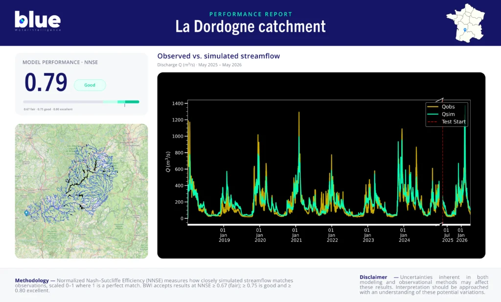
The improvement from training (0.75) to testing (0.79) is notable — the model generalises well to the independent test period, a strong indicator of robustness on an operationally complex, heavily regulated system.
The standard deviation of 0.17 and minimum NNSE of 0.07 reflect genuine localised complexity rather than a systemic model weakness. On a catchment of this size and dam density, a small number of stations are subject to highly localised regulation effects — reservoir releases, inter-basin transfers, or tributary confluences with atypical dynamics — that a basin-scale model cannot fully capture without site-specific parameterisation. The two underperforming stations are flagged for investigation in the next retraining cycle. The high area-weighted mean of 0.88 confirms that these outliers correspond to smaller sub-catchments with limited hydrological weight in the overall network.
A catchment-area-weighted NNSE of 0.88, with 19 of 27 stations above 0.80, places the Dordogne model among BWI’s strongest operational deployments. At this performance level, the model reliably captures not only seasonal flow cycles and flood event timing, but also peak flow magnitude at the majority of monitored locations — the most demanding operational requirement for a heavily dammed, multi-tributary system like the Dordogne.
For hydropower operators managing reservoir inflows and energy production planning across the 56-dam network, this translates into reliable 10-day discharge forecasts with sufficient accuracy to support day-ahead trading and flood damage prevention decisions. For EPIDOR and basin management authorities, the model provides a consistent, basin-wide picture of flow conditions across 1,394 reaches — including tributaries where physical monitoring remains sparse.
The two stations with low scores are a known and bounded limitation: they affect localised sub-catchments and do not compromise the operational reliability of the model at the main stem and primary monitoring points. Targeted retraining at those locations is planned for the next model cycle.
Overall, this is BWI’s highest-performing model on a French catchment by area-weighted score, and demonstrates the robustness of the approach on a regulated, ecologically sensitive, and operationally complex river system.
Interested in forecasting performance for your catchment? → Request a demo
For an explanation of the performance metrics used in this report — NNSE, NSE and their respective thresholds — see our model performance methodology page.