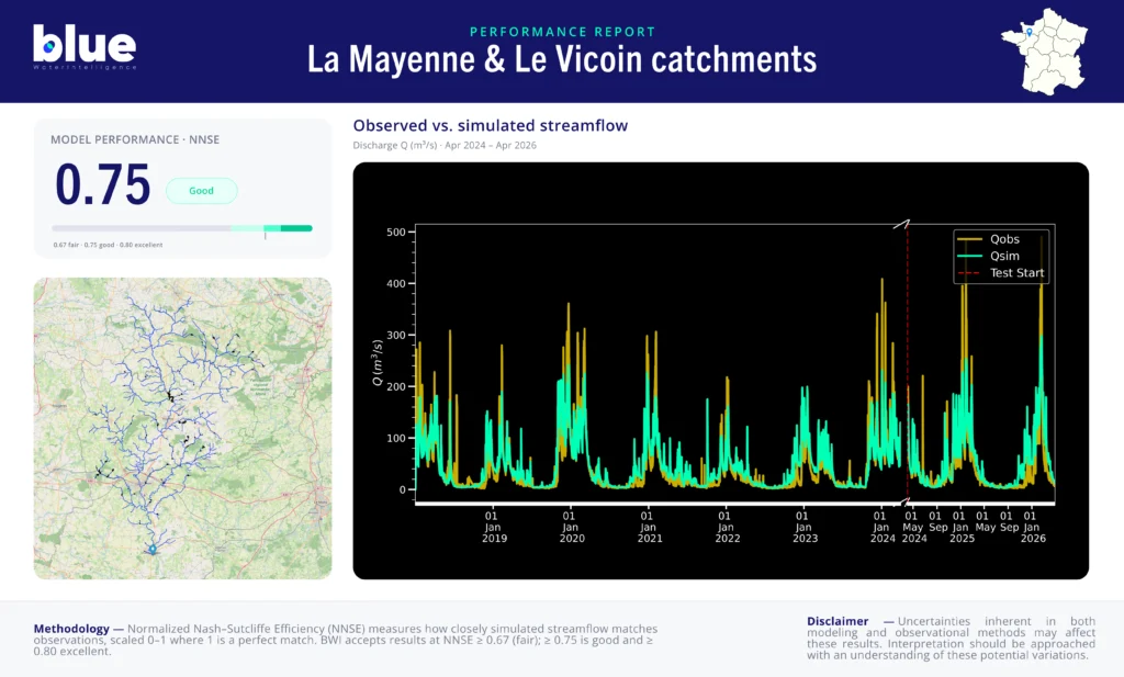
BWI’s hydrological model for the La Mayenne and Le Vicoin catchment in western France achieves NNSE 0.75 on the testing dataset (April 2024 – April 2026), consistent with training performance (NNSE 0.76). Across 16 validated stations, 15 exceed the deployment threshold of NNSE 0.65. The model reliably simulates baseflow dynamics and seasonal flow variability on a slow-response, dam-regulated river system where oscillation control and low-flow accuracy are the primary operational challenges.
The La Mayenne and Le Vicoin catchments is located in the Pays de la Loire region of western France, in the Mayenne department. It covers a total drainage area of 3,901 km², comprising 679 river reaches across the two rivers. The Mayenne rises in the foothills of Mont des Avaloirs at 293 metres elevation and flows 202 km southward before joining the Sarthe and the Loir to form the Maine, a tributary of the Loire. Le Vicoin is a right-bank tributary of the Mayenne, 47 km long, rising near Bourgneuf-la-Forêt and joining the Mayenne downstream of Entrammes.
The catchment sits entirely on the Massif Armoricain, a geological context that limits significant groundwater storage and makes river flow largely dependent on surface runoff and precipitation. The hydrographic network includes the Mayenne and its main tributaries — the Aisne, Gourbe, Vée, Égrenne, Varenne, Colmont, Aron, Ernée, Jouanne, Vicoin and Ouette. The network includes 18 hydrometry stations and 2 EU Hydro dams, reflecting a regulated river system with hydroelectric infrastructure. The climate is oceanic, with moderate seasonal variability and a dominant winter-spring high-flow regime. Le Vicoin is noted for high flow irregularity, with severe low-flow conditions during summer, reaching as little as 18 litres per second at étiage.
The primary water management challenge on this system is flow regulation across a large, multi-tributary network — balancing irrigation, hydropower, ecological flow requirements, and flood anticipation across a heterogeneous catchment with significant seasonal variability.
The model achieves NNSE 0.76 on the training dataset (January 2018 – April 2024) and NNSE 0.75 on the independent testing dataset (April 2024 – April 2026), demonstrating stable, consistent performance across both periods. The near-identical train and test scores indicate the model generalises well and is not overfitting to the training period — an important quality signal for a multi-year operational deployment.
Across 16 validated stations, performance is highly consistent: 15 of 16 stations exceed the NNSE 0.65 deployment threshold, and 2 stations achieve NNSE above 0.80. The catchment-area-weighted mean NNSE is 0.76, with a low standard deviation of 0.05 — indicating homogeneous performance across the network rather than strong results at a few stations masking weakness elsewhere.
With NNSE 0.75 and 15 of 16 stations above the deployment threshold, BWI’s model on the La Mayenne and Le Vicoin catchments is well-suited for operational 10-day discharge forecasting. Basin managers, irrigation planners, and hydropower operators across the Mayenne network can rely on the model for seasonal flow anticipation, low-flow monitoring, and flood onset detection. The spatial consistency of performance across 679 reaches makes this model particularly valuable for multi-point monitoring across the full river network, rather than at a single outlet.
Interested in forecasting performance for your catchment? → Request a demo
For an explanation of the performance metrics used in this report — NNSE, NSE and their respective thresholds — see our model performance methodology page.