On this continuously updated page, BWI answers your frequently asked questions (FAQ). It aims to support and simplify your research before discussing your needs with our sales representatives. If you can’t find the answer to your question, please contact us via the form below. We’ll aim to respond to your queries promptly.
Our 4-word pitch is: ‘BWI digitizes river basins‘.
As a provider of virtual stations anywhere on water bodies, BWI brings together more than 60 data types, hydrological and hydraulic models, and machine learning, in particular, neural networks, to:
– deepen scientific knowledge in hydrology,
– help businesses adapt to an era of climate change-induced water stress,
–better predict water-related hazards such as floods, droughts, and water pollution.
At BWI, a virtual station refers to a digitized measurement point located on a water body.
BWI provides its customers with the possibility of creating as many virtual stations as necessary without having to physically deploy any ground station.
Virtual stations may be deployed anywhere on the hydrographic networks covered by BWI.
Today, virtual stations can provide near real-time estimates and forecasts of river flows.
Tomorrow, BWI will also forecast water levels, volumes, and quality of continental freshwater.
The comparison between virtual stations and physical in-situ monitoring stations can be found in the table below:

Of course! BWI gathers data from sources showcased in the infographic below:
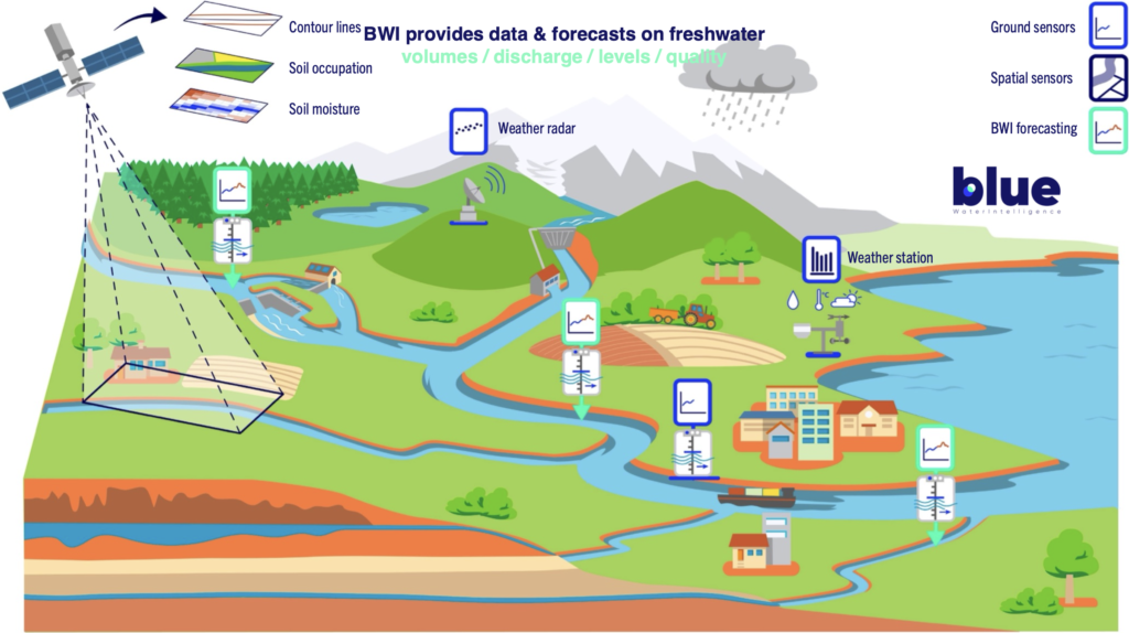
As far as data sources from space sensors are concerned, BWI uses multiple satellites with onboard sensors ranging from radars, altimeters, radiometers, and imagers. This variety of sensors allows BWI to retrieve earth observation parameters on terrain characteristics, soil moisture, land use, precipitation estimation, and snow cover-up to surface water quantity and surface water quality parameters.
More precisely, BWI leverages Copernicus EU data products extensively in its semi-distributed hydrological modeling for river flow forecasting across European basins. BWI’s core technology deploys a semi-distributed hydrological model that discretizes river basins into hydrological response units (HRUs). In fact, Copernicus program products lie at the heart of BWI river flow forecasting service.
The fundamental part of the system – river network – is based upon EU-Hydro, a Copernicus Land Monitoring Service dataset, which provides a river network with surface water bodies and drainage model West of Ural. East of Ural river and in other parts of the world, BWI uses HydroSHEDS for river networks. Alongside EU-Hydro and HydroSHEDS, BWI, uses EU-DEM, a Copernicus digital elevation derived from ASTER and SRTM data. The system prioritizes EU/EC-derived datasets, including the Copernicus Land Monitoring Service’s EU-Hydro River Network Database, which provides EU-dem based river segments consistent with surface water body interpretations from lakes and wide rivers across EEA38+UK.
Those two products define most geometric properties of the simulated systems (river basins). For basin surface description, BWI uses ESA dataset WorldCover, derived from sentinel 1&2. For soil properties, we use SoilGrid250m. Those two datasets are used to derive the dynamical and statical properties of HRUs and determine runoff generation properties.
Snowmelt and evapotranspiration modules employ FAO-56 Penman-Monteith with EU-Hydro-derived canopy parameters and albedo from Sentinel-2 composites processed via Copernicus services.
By default, data assimilation/state correction is applied, BWI typically uses Reduced-rank Square-root Kalman filter with sparse formulation suitable for high-dimension system to update model state.
Forecast horizons extend to 10 days at 10-minute time steps, with probabilistic outputs from 51-member ECMWF ensembles downscaled via quantile mapping to EU-Hydro/HydroSHEDS catchments.
BWI also uses Sentinel-1/2 indirectly via EU-Hydro (built on SPOT-5/6, SRTM, ASTER auxiliaries) and derived CLC products and directly for feature prototyping.
Catchment delineation employs EU-DEM flow direction grids (D8 algorithm) for sub-basin nesting, ensuring consistency with pan-European hydrographic standards for EEA38+UK.
Groundwater baseflow is modeled via linear reservoirs calibrated to EU-Hydro/HydroSHEDS low-flow indices (Q95) and spring discharge observations from WISE database.
Flood wave attenuation incorporates dynamic wave approximations where channel widths exceed EU-Hydro/HydroSHEDS photointerpreted thresholds (>50m).
The platform exposes forecasts via a REST API, with virtual station deployments customizable to client-specified EU-Hydro/HydroSHEDS river segments for flood early warning, hydropower optimization or irrigation regulation.
Model validation benchmarks against national services (e.g., Vigicrues), achieving Nash-Sutcliffe efficiencies >0.75 on 70% of 500+ calibrated basins.
Future enhancements integrate EU-Hydro 2.0 (planned) for improved wide-river mapping and Copernicus Anthropogenic Pressure layers for human influence corrections.
This EU-centric data stack enables BWI to deliver global scale, gauge independent forecasts resilient to data gaps in transboundary basins.
BWI processes data as stated in the following infographic:
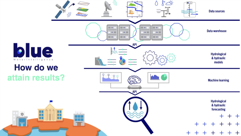
A set of different models are currently combined at BWI: rainfall-runoff as well as snow melting models for hydrological purposes, physical models to integrate meteorological parameters, recurring neural networks to keep the models calibrated, and machine learning algorithms to refine the results of previous models against the acceleration of climate change.
The acronym BWI stands for Blue Water Intelligence. It should be read as ‘Blue; waterintelligence’, with ‘waterintelligence’ as a tagline.
We commonly refer to the company as BWI, and our talents are ‘Bluers’.
BWI conducts its business guided by a set of 4 core values shared by all Bluers:
– Meaning, given that all talents who have decided to join BWI are here to make an impact on society, that is to say, to work to offer solutions to several pressing problems. To name just a few of these pressing problems:
– understand the effects of climate change on the water cycle and contribute to science by sharing findings with the hydrological research community,
– help businesses and authorities adapt to climate change-induced water stress,
– help the development of hydropower and inland waterway transportation to accelerate the transition to a low-carbon society,
– evaluate inland water reserves,
– monitor surface water quality,
– in case of a water-related hazards, warn populations early to contribute to saving human lives.
– Innovation and creativity in everything we do at BWI, particularly by promoting a culture in which everyone is challenged and is encouraged to challenge other people’s ideas. We at BWI pledge to take time to look at problems from radically different vantage points and provide non-conventional solutions that will favor results and speed to trigger movement and change.
– Global mindset, since the water crisis is everywhere and the stakes are universal.This means our team has to reflect this global mindset: it is only by gathering diverse skills, cultures, and experiences that will combine into something uniquely different and new that BWI will be capable of coming up with unprecedented solutions applicable worldwide.This is why BWI will always favor diversity and inclusiveness over conservatism and business as usual.
– Excellence, as BWI wishes to work with the best talents, for the most demanding clients, for the most renowned suppliers, and with the most prestigious stakeholders in general.BWI not only wants to continuously raise its standards but continue to set the bar even higher to ensure continuous growth at and beyond BWI.
Partially. Our river discharge hydrological forecasting services are already operational. As of 2024, BWI’s virtual stations provide river discharge forecasts and near-real-time estimates in Europe (France, Belgium), South Asia (India, Nepal, Bangladesh), and Africa (Senegal, Uganda). What’s more, our early warning system is equally operational.
BWI is continuously adding new capabilities to virtual stations, such as water levels of rivers and lakes, water volumes of water bodies, and water quality monitoring and forecasting.
BWI’s basin digitization services are hosted in the European Union. BWI’s provider of server infrastructure is Scaleway, a French company operating data centers in Paris, France, Amsterdam, Netherlands, and Warsaw, Poland. BWI teams manage servers themselves.
Scaleway’s data centers run on renewable energy exclusively, mainly coming from hydropower.
No. We’ve been developing the first 2 nano-satellites (550km inter-tracks, 48-hour revisit rate) of the constellation, aimed at validating all technical assumptions and commercializing data to the market.
This 2-strong ‘minimum viable product’ will be the perfect ground base to raise further capital to launch a space infrastructure of at least 10 nano-satellites, and who knows, maybe 80!
Yes, BWI is always looking for the best talents to join the Blue team.
Talents join BWI primarily for our mission: aiding public authorities and businesses in adapting to climate-induced water stress.
Additionally, BWI offers competitive packages, a flexible yet driven work environment, and a healthy work-life balance.
If you feel you are the right fit, don’t hesitate to contact us via the BWI careers web page.
BWI’s run-of-river hydropower river discharge forecasting service is exclusively designed for run-of-river HPP operators, both small and larger HPP operators.
BWI was founded by Hemeria Invest, a private holding company currently controlled by several European investors. From BWI’s creation in June 2022 to January 2024, Hemeria Invests fully owned and controlled BWI.
However, when BWI increased its capital in January 2024, Hemeria Invest became a minority shareholder. Hemeria is now holding less than 10% of its shares.
Both companies share the same entrepreneurial spirit and drive for excellence and innovation.
No. BWI is a service vendor and a data provider.
BWI has selected a number of in-situ sensor manufacturers from whom it purchases necessary hardware.
BWI is a client in the physical ground measurement industry, not a competitor or supplier. BWI is open to connecting with equipment providers worldwide.
However, BWI doesn’t set up physical stations for their clients. Contrarily, BWI offers a licensing service to virtual stations.
No. BWI’s focus is on providing quantitative and qualitative data related to inland surface water. Subterranean water and surface water are undeniably linked in many ways, but BWI isn’t looking at the former.
BWI’s 1 to 4-day hydrological forecasts can be considered reliable, supported by satisfactory performance and high NNSE testing values. It has to be mentioned that 10-day hydrological forecasts represent a general trend, equally reflecting the changeability of meteorological forecasts.
BWI is working hard on improving the accuracy of its forecasts as well as on providing clients with a continuously updated BWI data accuracy index, maintaining transparency.
No, BWI isn’t a consultancy and does not offer consulting services.
When and if consulting services are required for any of our basin digitization projects, BWI partners with consultants or recommends consultancies to clients.
No. Trial periods exist, but the service will still be charged.
Of course you can! During your trial period, only the months consumed will be charged – so you’ll get refund for your payment if need be. Once your trial period is over, your service will be cancelled but only at the end of your licensing plan. Meaning renewal won’t occur if you’ve duly cancelled.
Assuming the water body of interest to you belongs to a watershed represented on BWI’s hydrographical network, BWI will be able to provide near-real-time hydrological estimates and forecasts for your selected water body.
However, BWI knows by experience that for water bodies below 50 square kilometers, it’s harder to reach a satisfactory river flow forecasting performance.
Yes. BWI’s hydrological forecasts are designed to operate globally. If you need surface water forecasting for a region not yet covered by BWI, please get in touch with us. We may expand our service coverage to your area of interest.
One user can not combine different licensing plans. However, an organization may subscribe to different BWI plans (Silver, Gold, Platinum) by signing more contracts simultaneously. In this instance, each account has to be accessed by a different user.
For example, a single user cannot combine virtual stations from Silver and Gold licensing plans. Each account must include virtual stations of the same plan for technical reasons (e.g., SLA couldn’t be applicable otherwise).
Ask BWI
a question